
I’ve been posting a lot about what I’ve been doing in London, but I haven’t talked much about how I actually get around such a big city. I did discuss it in a post I did last year when I visited London with a friend, and briefly when I visited Sight Village in 2016, before I actually lived here. But now I’ve been a resident here for a while, and as new followers have asked about it recently, now’s a good opportunity to revisit the topic in more detail. So I’m going to split this over a couple of posts, starting with how I plan my journeys before I actually do them. Then in my next post I’ll talk about what it’s like travelling around.
I’ve also made a video to go with these posts, which you may like to check out as well.
I cannot drive due to my visual impairment, and I don’t live with anyone can drive either. So I have to rely on public transport to get around. And to plan my journeys, I use a few apps and websites, depending on where I’m going and how well I know it already. I basically try to get as much familiarity with the route and the destination as I can, before I actually travel, as it just makes things easier and makes me more confident getting around.
It’s important to note that I’m not affiliated with, or sponsored by, any of the apps or websites I’m about to mention. These are purely my own opinions and experiences. And if anybody knows of other apps or websites they think I should try, then do let me know, I’d be happy to try them out and review them.
Contents
Citymapper
This is the first thing I use whenever I’m planning a journey. Citymapper is an app for iOS and Android that covers a lot of cities worldwide, including Birmingham, Manchester and London in the UK. And I cannot sing its praises highly enough. I don’t know how accessible it is with things like Voiceover, but from a visual perspective I’m very comfortable with it.
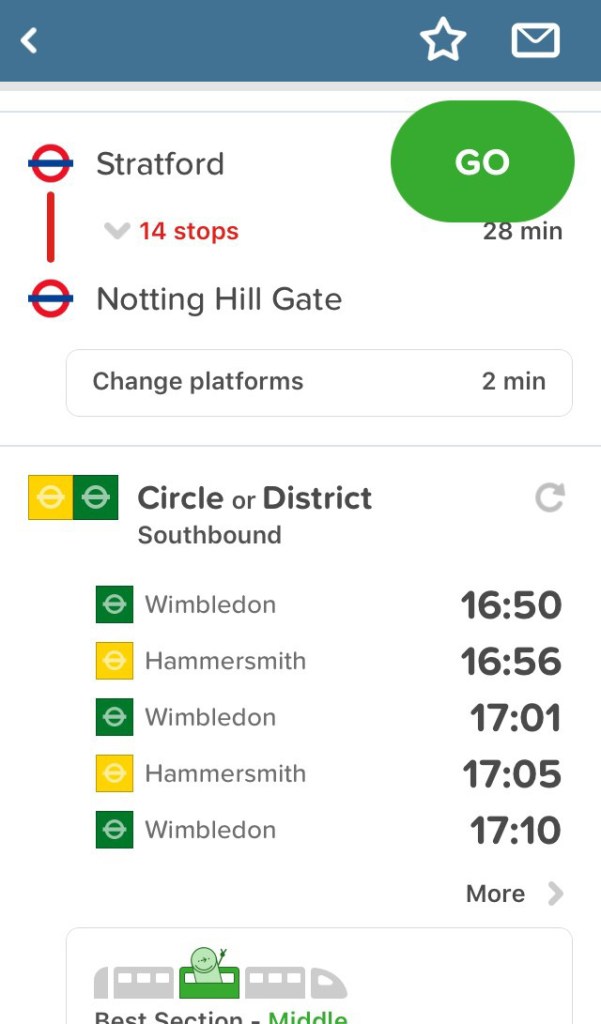
You basically type in where you’re going, and it’ll tell you the quickest ways to get there by various means i.e. walking, cycling, Tube, bus, train, tram, driving your own car, etc. It gives you a lot of detail about each aspect of the journey too (how long each stage will take, when the next Tube, bus or train service is arriving, walking directions on the map, which Tube carriage to be on so you can get off right by the station exit etc).
I’ve found the estimated times to be very accurate, assuming an average walking speed and no unforeseen delays of course. It will assume you want to leave for your destination from where you currently are right now – but you can customise all of that too. You can specify a different place to leave from e.g. if you’re checking the route between two places for future reference. You can specify a future time and/or date to get an estimate of how long it will take you. And if you need to be somewhere by a certain time, you can tell it the arrival time, and it will tell you when you need to leave by.
It also takes into account any closures of stations and lines due to engineering works or other incidents, so it will only ever suggest routes you can actually take. Because it always suggests multiple possibilities, if the option that is usually quickest is reporting delays, then I can just pick an alternative that dodges the delay completely (e.g. getting a bus to a different Tube station so I can pick up a different line – usually the difference in time is minimal anyway).
If you’ve told it your home address, you can easily find the quickest way back by tapping “Take me home” when you’re out and about. You can set your work address too, but as I’m a homeworker that’s of no use to me. You can also see status updates for all lines, and you can ask it to send you notifications when one of your favourite lines has an unexpected issue. You can also get notifications when you’re on a trip, so it can tell you when to get off the bus or train. It also includes a Tube map, including a version with the National Rail lines included as well, along with a Night Tube map too. You can also find maps on the Transport For London website of course.
And if you’re really lucky when you ask it how to get somewhere, it’ll add a humorous option at the bottom like a jetpack or catapult, just to show long that might take! There is an element of fun and humour to the app, including in the descriptions of their updates, but it’s very low-key and not the focus. It’s just a bit of fun on the side. You get the impression that the developers enjoy tinkering about with it, in a good way.
So it’s extremely comprehensive and I find it really useful. The only feature of it I’m not a big fan of is the Telescope. The theory behind it is nice, in that it brings up your destination on Street View so you can get a visual of it. And for many people it’s probably fine. But in practice I don’t use it myself. It doesn’t always drop you in the correct part of the street, and will even place you in a different street nearby if Street View doesn’t cover the one you want. And, more significantly, it’s displayed in a small circular window so you can’t really see a great deal, whereas on the actual Street View app or website you can see it full screen. So that brings me on to the next service I want to talk about.
Google Maps & Street View
Google Maps is also a very useful way of getting directions to a place, especially if I’m walking somewhere. Sure, Citymapper can guide you very nicely, and the green triangle on its map is useful for seeing where you’re facing, so that’s perfectly adequate sometimes. And Apple Maps isn’t bad either, though somehow I’ve not taken to that quite so much. But sometimes I just prefer the Google Maps interface for guided walking directions as well. The map is generally very clear, with a nice big arrow on it and a thick prominent line of dots to indicate where you should be walking. And it talks to you if you want it to as well, meaning you can just plug your earphones in and keep your phone in your pocket, which is ideal.
If I’m in an area with a complex road layout, and there are a few such places in Central London, then it may take a moment to get my bearings and head in what I believe is the right direction. It can get a bit confused occasionally, or so it seems to me. But once I’m sure I’m heading the right way, the app is very good at guiding me.
Once I’ve got walking directions from Citymapper or Google Maps, I then follow those directions in Google Street View, meaning I virtually walk the route (this is still assuming I’m planning a journey while at home, obviously, not when I’m physically in the street itself). I usually do this on my Mac computer at home so I can see it clearly on my big screen, but sometimes it’s handy to use the Street View app on my phone as well. As I said earlier, there can be occasions where Street View doesn’t cover the street you want or fine. And sometimes you might get somewhere and find there are diversions due to roadworks or building work. But the vast majority of the time Street View is very useful.
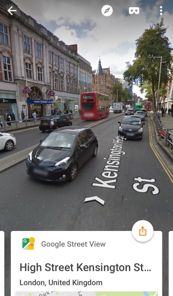
By using it to walk the route once or twice, in both directions if I know I’ll need to go back the other way too, it helps me to feel familiar with the area and the route I need to take. So when I actually do it, I’ll be less likely to get lost, because I’ll recognise various landmarks and points of reference. It’s a lot easier to do that than find street signs, because I can’t read those without getting up close or using my monocular, especially in Central London where lots of street signs are high up on the walls.
Landmarks and reference points can take many forms. It may be a simple case of counting side roads down a long street until I find the one I want. Often there are distinctive buildings that I can look out for. Or there may be a big junction like a roundabout or a big set of traffic lights that I need to pass. Maybe I have to use a bridge over a river or railway line, or there’s a big park or garden space on the route, or there’s a big postbox on the corner of the road I have to turn into. And so on, there can be all sorts of things. Sometimes the Street View image can be a bit out of date, so you might find that one or two shops have changed for instance, but for the most part the static landmarks will stay the same – buildings, railways lines, bridges, etc very rarely move!
So it just makes me feel a lot more confident about doing a new route, because I’ll recognise various elements of it as I go along. I may occasionally have to call upon one of my map apps when I’m at the location if I get disorientated or the route is a bit complicated, or if I just need to refresh my memory a little bit, but a lot of the time I don’t need to do that after using Street View.
Building Interiors
Another cool aspect of Street View is that it can sometimes take you inside buildings, including a few pubs, museums and stations. That’s been really useful as well, so I can see the layout of the place. Sometimes it’s helped me to figure out where the toilets are, for instance, so I don’t have to look around for someone to ask when I’m there.
For example, I was able to use this when meeting South East London Vision at The Partridge in Bromley recently, and I also remember using it at the Counter bar in Vauxhall, as well as Drink, Shop & Do in Kings Cross. One of the coolest secrets of Street View, though, relates to the Tardis phone box outside Earls Court Underground station. In real life you can see it in person, but you can’t go inside. However, if you look it up on Street View, you can pass through the doorway and take a virtual walk around the Tardis set from Doctor Who, which is awesome!
Street View won’t show you inside most buildings though, obviously. So if I do want to peek inside a venue I’m unfamiliar with, I’ll look up photos instead, on the venue’s own website and/or Google Images, just to get a feel for what the place looks like and how it’s laid out. It might not show me everything, but it’ll give me a sense of what to expect. Looking up a photo of a place can also help me to find it in Street View occasionally, if it’s a non-descript building that isn’t clearly jumping out at me initially.
And sometimes looking up photos has been enough to help me decide whether to go somewhere in the first place or not. If I’m thinking of going to an event, but I look up the venue and it looks likely to be really dark or difficult to get around on my own, then I’ll probably avoid it. I would only consider going to those kind of places with someone I knew who could guide me around.
Station Interiors
It’s also worth mentioning Tube and National Rail stations, because there are ways to check those out in advance too.
For the Tube, I sometimes use the StationMaster app for iOS, developed by Geoff Marshall (from All The Stations) and Matthew Frost. It’s a comprehensive guide to all the stations on the London Underground, London Overground and Docklands Light Railway. Not only do you get a copy of the Tube map, and a map for each station telling you where it is, but you also get 3D maps of the interior of each station too. These naturally require vision to understand but, if you can see them, they’re very well done, showing you where all the platforms, stairs, escalators, exits, etc are found.
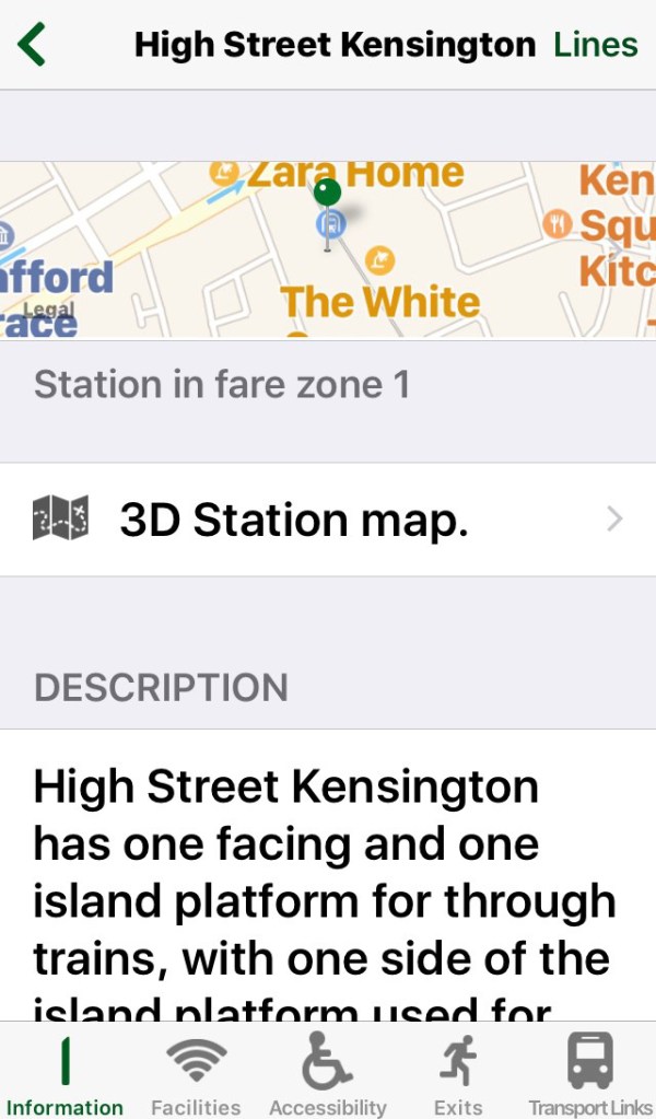
And on top of that, for each station you get little nuggets of history and fun facts, details on whether it’s served by the Night Tube, a list of station facilities, a set of accessibility notes for disabled travellers, details of the station exists, and details of the local bus routes. There’s so much information in here, and all very nicely laid out, so it’s handy to have.
As for all the mainline rail stations in the UK, you can use the Stations Services & FAcilities feature on the National Rail Site. I only discovered this by chance – I had no idea it was there because I’d never thought of looking before. But if you search for a station, then scroll down and expand the Station Map option, and then hit the View Large Version link., you’ll be presented with a large, interactive map of the station. If you hover your mouse over each item on the map, a box will pop up with a brief description and a photo of that part of the station. You can then click on the photo to see the enlarged version. So the map and the photos can give a pretty good sense of what to expect, assuming you can see them well enough.
Incidentally, when it comes to planning journeys on National Rail services, I tend to use the Trainline site for that. Again, it’s just a case of typing in where I’m going from and to, and it’s pretty clear at telling me the quickest and cheapest routes, so it’s nice and easy. I know there are probably cheaper ways of doing things, be it through other websites or by using tricks like split ticketing, but I haven’t looked into that closely as I don’t use national rail trains very often. So if people know of other websites I should consider booking trains through for future reference, by all means comment and let me know.
Conclusion
So those are the main ways I plan my journeys. Once I’ve figured out the basic route I use all the visual tools I can, to find out how to get somewhere and gather information about the place itself. It might not tell me absolutely everything, and I may not use all of those tools for any given trip – it depends how unfamiliar it is and how easy it seems to get there. But all the information I do find out in advance makes life easier later on, because it means I have some familiarity with the route and the destination before I arrive. The internet and smartphones have made journey planning an awful lot easier than it used to be, it’s wonderful.
So I hope you found that interesting. In my next post I’ll write about what it’s like actually travelling around London in general, as that’s something I get asked about too.


5 thoughts on “Planning My Journeys In London”